Sunday March 29th, 2020
Meet at the Trailhead at 9am
at the ramada next to the restrooms
Tom’s Thumb Trail (short way)
23015 N. 128th Street, Scottsdale
What better way to inaugurate a new season than to climb to one of the Valley’s iconic geological features for tantalizing views and a chance to build your checklist of places to hike over the coming cooler months?
Tom's Thumb Trail is a popular 5 mile out-and-back trail located near Scottsdale, Arizona that features WILDFLOWERS and is rated as difficult.
Start your new year off with your resolution to get back in shape!
From the Tom’s Thumb trailhead, the path begins with a moderate warm-up section before switchbacks ascend among massive granite outcroppings and classic desert vegetation. After roughly 300 feet of climbing, mountain vistas to the north and east begin to shine.
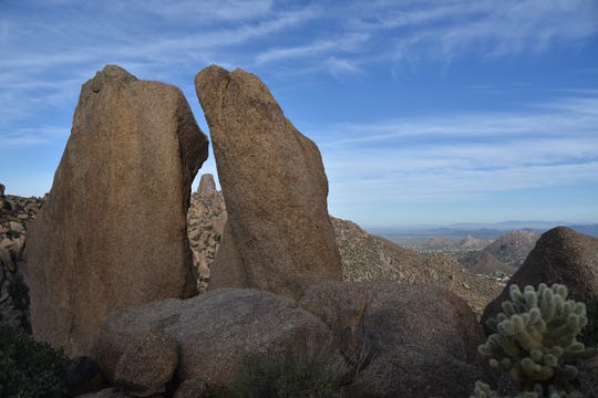
At the 2-mile point, the major climbing ends where a short spur path leads to the base of Tom’s Thumb. Visible from many spots around town, the soaring lump of craggy granite is even more impressive up close.
The 0.3-mile spur entails some minor scrambling to reach the goal. Wander around Tom's Thumb perimeter to see shallow caves and a cathedral-like corridor with a breezeway that opens to views of Elephant Mountain in Spur Cross Ranch Conservation Area and peaks of the Cave Creek Mountains and Tonto National Forest.
Hikers are treated to gorgeous views of the southern Mcdowell Mountains and urban Phoenix.
Getting there: Tom's Thumb trailhead, 23015 N. 128th St. Scottsdale.
From Loop 101 in Scottsdale, exit at Pima/Princess Road and go 5 miles north on Pima to Happy Valley Road. Turn right (east) and go 4.1 miles to Ranch Gate. Turn right (south) on Ranch Gate, go 1.2 miles, then turn right onto 128th Street and go 1 mile to the signed trailhead. Roads are paved.
The preserve is open from sunrise to sunset daily.